.. THE �OLD COL� (SPRINGVALE) IN THE 1960`s ..
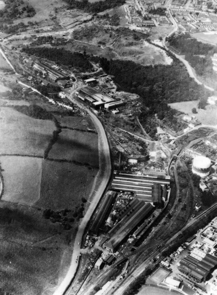
Key
1. Maendy Way
2. Adit Walk/Broad View/Wimborne Rise
3. Main Adit (in the woods)
4. Former Colliery Offices, in the 1960s, a farm
5. Site of row of workers� cottages
6. Semi-circular and collapsed tunnels
7. �Bugs� Prop�
8. �Water Adit�
9. Remains of hopper at coke washery (demolished 1960s)
10. Shale extraction area
11. Main GKN foundry
12. Greenforge Way
13. Clomendy Road
14. GKN Precision Forgings (�The Malleable�)
15. Old blast furnace
16. Monmouthshire-Brecon Canal
17. GKN administration
18. Monmouthshire Eastern Valleys Line
19. Council landfill site
20. Engine and Boiler houses for the Main Adit
As a child, the �Old Col� as we called it, was a magical adventure playground. Its varied terrain, hills, little valleys, undergrowth, woods, streams, and derelict buildings offered wonderful scope for cowboys and Indians, British and Germans, damming streams and a host of other activities. Later, I cut bean poles for my father from the woods, and scavenged discarded chestnut fencing from the landfill site (19) for chopping up into kindling.
One dangerous and pointless pastime was looking for scraps of lead, often old piping, then melting it in an old pan over a fire. There were always bits of lead over the Old Col (alternatively known as the colliery fields, but rarely in my childhood as Springvale). I can�t remember why we did this, especially as I poured some molten lead on my arm once, but it never stopped me. Perhaps we had an innate foundry/smelting instinct passed down from previous generations.
Of course, the Main Adit (3) was still visible then, even if partially built up with earth and hidden in the undergrowth, and the ruins around this area another good playground. Further up the old incline was a small farm which had once been the colliery offices (4). Through the hedge you could see pigs snuffling around. Today, the buildings have disappeared, subsumed into the Greenmeadow Community Farm. In the spring, the wooded slopes around the adit were, and still are, covered in bluebells. My mother always welcomed an armful of these for a vase in the living room. The adit was arched, with �1879� engraved into the keystone. It had been bricked up and unlike the �Water Adit� (8) I can never remember these being knocked in. An erstwhile neighbour, Mr Jarrett, was on the last ever shift there and complained to me of how they were made to keep hard at it to fill the drams right up to the end of the shift, knowing the coal was going nowhere. As they trooped out of the mine, the bricklayers were waiting to seal the entrance, leaving the entire shift�s output in the drams where they are doubtless still today, rotting.

.. The Main Adit January 2008 ..

.. The Main Adit in 1976 ..

�and in its working days
Down from the adit, up against the high wall, was an allotment known as �Bugs� Prop� (7), tended by a local family from, I think, Broad View. As stated elsewhere on this site, this allotment was turned, against local advice, into a water fowl pond, creating the boggy, overgrown morass that is there today.

�Bugs Prop� January 2008 � a morass
On top of the high wall, there were a couple of tunnels about three feet high (6). One was semicircular, so you could crawl in one end and out the other; the other tunnel was caved in after about twenty feet, causing a feeling of uncertainty about the stability of the other one! They made excellent �dens�, and from there, was a panoramic view over the Old Col. To the front of the tunnels was another steep wall at the foot of which was a long network of open channels about three feet deep, but then, mainly filled with rubbish and undergrowth. This installation was constructed of stone. It is said that a cableway supplied the coke plant and washery (9) from the adit, possibly this installation was connected with this.
At the base of the high wall was the �Water Adit� which had a large stream flowing out of it. In those days the entrance was not fenced off with railings, and the bricks with which it was blocked were frequently knocked in to give illegal access.

.. The Water Adit January 2008 ..

.. and behind the railings ..

.. The Water Adit in 1976 ..
The keystone was engraved �RJB & Co� (RJ Blewitt & Co). In the 1960s/70s a local in Adit Walk used to go into the old mine workings to dig coal for his fire, possibly here. Not a sensible thing to do as on one occasion, as always, alone, he was trapped by a fall. Nobody would have known where he was, he would have simply disappeared (literally) from the face of the earth. Fortunately he managed to dig himself out.
At the coke plant (9) there used to stand a huge concrete hopper like a kitchen funnel. It was possible to crawl inside it through a small passageway at the base and look up at the sky, and shout out, using it as an echo chamber. Around it was a complex of derelict buildings of stone construction with yellow decorative bricks around the windows. This backed on to the woods and was itself very overgrown. There were various inspection pits, mostly uncovered and I remember one day finding one with the perfect skeleton of a medium sized dog which must have fallen into the approximately six feet deep pit and then, unable to get out, died a wretched death. This complex was demolished in the 1960s, the hopper being blown up by the Royal Monmouthshire Royal Engineers (TA). I was fortuitously at Springvale that day, and saw it blown up. It was then semi bulldozed over and left for years looking as it does in the above aerial photograph.
Across the track from the coke plant was the line where a terrace of workers� cottages had stood, referred to as Springvale Cottages (5). There was nothing left of them except their outlines and the traces of their back gardens. I used to poke around here a lot, finding shards of pottery and also, many .22� LR empty cases. Some of the original domestic flowers still used to grow. There were also a lot of rabbit skulls, some with .22� holes in them. I always imagined the workers there supplementing their diet with rabbit, still plentiful on the upper slopes of Springvale during my childhood. For some reason, the old back lane to these cottages was a favourite dumping place for old cars, another great playground toy. I still have a Standard 8 enamelled radiator badge from one of them.
At (10) was an area exploited for shale for the foundations of Llanwern steelworks, built in the 1960s. At its heyday, this was a dangerous area; there was a fortune to be made from hauling this shale to Llanwern, and many cowboy operations were set up to cash in. Lorries would drive furiously up and down, reminiscent of the film �Hell Drivers� with Stanley Baker and Patrick McGoohan. It was rumoured at the time that Shirley Bassey invested some of her money in a few lorries and drivers, and made a killing. Once the shale bonanza was over, there was a column of shale left in the centre of the area, looking like Cwmbran�s own Old Man of Hoy.
In the wood at the bottom of Wimborne Rise was another installation, (20) in stone, consisting of a network of channels similar to that mentioned above, but smaller. Again, this was filled with rubbish; I have no idea what its purpose had been. Today it is dug up and bulldozed over, covered in undergrowth, a depressingly familiar story when it comes to the (lack of) preservation of our industrial heritage.
At the administration offices of GKN (17) there used to be either the Blewitt bridge span erected at the back of The Halfway in Cwmbran village, or another, there having been two in existence. I remember it there by the personnel office when I went there for a job in the summer holidays of 1968, spending six weeks at the �Malleable� (14).

.. The Blewitt bridge span ..
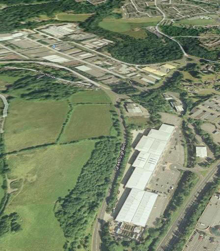
.. Springvale in 2007 ..
Key
1. Maendy Way
2. Adit Walk/Broad View
3. Main Adit
4. Water Adit/�Bugs� Prop�
5. Springvale Industrial Estate (Formerly GKN and bulk of �Old Col)
6. Blast Furnace Wall (with old Ardep building)
7. Gasometer site
8. Cwmbran Retail Park (site of Precision Forgings, �The Malleable�)
9. Monmouthshire-Brecon Canal
10. Greenmeadow Community Farm
11. Cwmbran Drive
As can be seen from comparing the two aerial pictures, taken about forty years apart, very little remains of the Old Col. Predictably, a promise by the council to �landscape� the area for the benefit of the community resulted in an industrial estate and a swamp, with a significant part of our heritage wiped out. One thing remains constant however, the blight of fly tipping which existed in the area in the 1960s, and remains today, is probably worse than ever.
(Contributed by Lawrence Skuse)